
Since I touched on New York City’s “Old” streets last week, it’s fair I take care of the “new” streets. In most cases, in place names, “new” is a city, street, park, etc. named in tribute to an already existing place; perhaps settlers have fond memories of the “old country” or the city or country they were forced by circumstances, war or famine to desert. That holds true in New York City’s name and locations therein, but not always: witness our first entry, New St. in the Financial District, which runs two blocks between Beaver and Wall Sts.
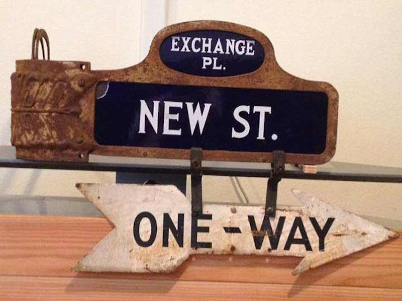
This sign, which hung at New St. and Exchange Pl. in the Financial District, is being auctioned on eBay for $43,000. I doubt that number will be the final auction price. In 1988, I purchased a similar sign in a lot at 6th Ave. and W. 28th St. for $50, and it’s still in my possession. I could get some considerable change for it but I’ll never part with it. This one still has its rusty bracket, used on cast iron posts in the years between the 1910s and 1960s, as well as an attached arrow-shaped one way sign (I’ve seen them with “NY Police Department” on the sign; nonetheless, I think this is authentic).
Incidentally, the brackets went with the signs like U goes with Q. Until 2000 or so, one of these sign-bracket combinations was still in place on a telephone pole at an obscure Bronx corner in Eastchester, Allen Pl. at DeLavall Ave.; unfortunately the Department of Transportation made quick work of it. I hope a collector was on hand when they removed it.
In recent years, the font used on these signs has been digitized and made available for download: if you’re a type designer, look for the font called Stickball. The signs, used in Manhattan and Bronx, were very dark navy blue and white—New York Yankees colors. I wonder if the uniforms were influenced by the signs. The first of these signs was produced around 1913, soon after the New York Highlanders began playing at the Polo Grounds and became the Yankees. New St. was new in 1664, the year it opened, just after the British took over New Amsterdam.

New Dorp is a transliteration of Dutch nieuw dorp, or “new town,” so called because it was settled in 1670, 10 years after nearby “oude dorp,” a name remembered in the street name Old Town Rd.. The town grew up around the junction of Richmond and Amboy Rds., where there were a proliferation of taverns serving stagecoaches and horse-drawn carriages. The Vanderbilt family was prominent in the area and owned several racing and trotting tracks in the area. The family helped found the New Dorp Moravian Church and Cemetery along Richmond and Todt Hill Rds.; the Vanderbilt Mausoleum, built for $1 million and designed by Richard Morris Hunt, can be found at the cemetery’s rear section.
The Art-Deco themed Lane Theatre, 168 New Dorp La. near 10th St., was developed by the Moses brothers, Charles, Elias and Lewis and opened in 1937 and designed by architect John Eberson; the first feature was “100 Men and a Girl” starring teen singing sensation Deanna Durbin. The Lane featured a modest 600 seats in its heyday, later reduced to 550. Until 2001, it had been recast as a nightclub that’s now closed, though the distinctive red and blue “Lane” façade is still visible. Its Art Moderne foyer and corridors remain intact, albeit inaccessible at present.

Astoria’s Newtown Road isn’t named for the neighborhood where it is, but for the town it runs to; Newtown, a former division of Queens County, is now roughly the neighborhoods of Elmhurst, Middle Village, Maspeth and Glendale. Like a number of NYC streets that run aslant the overall grid, Newtown Rd. is one of the older roads in the area. It’s a Native-American trail that became the main road to early Astoria settler William Hallett’s farm in the mid-17th century, and to the treacherous Hell Gate, the East River crossing to Manhattan. Its eastern stretch ended in the heart of Newtown, now Elmhurst, and was called Hurlgate, or Hellgate, Ferry Rd.; and later named for the town through which it passed, becoming Woodside Ave.. The road twisted and turned, to avoid topography like hills and swamps. It was once the sole road between the East River and the heart of Newtown, still the heart of Elmhurst at Broadway and Queens Blvd.
Pictured here is the Powhatan Democratic Club, 41-05 Newtown Rd. The sign looks much the same as it did in 1940. The political club is now officially known as the Powhatan and Pocahontas Democratic Club. Chief Powhatan (approx. 1547-1618), whose actual name was Wahunsenacah (spellings vary since the Native-American tribal leader didn’t spell his name in English) was a leader of the Powhatan faction of an alliance of Algonquin people living in what is now the Tidewater area of Virginia; Powhatan and his daughter, Pocahontas, were encountered by British settler Captain John Smith in 1607.
Established in 1900 or 1901 (the sign and the website give different dates) the Powhatan is one of the oldest extant political clubs in the country. The building itself goes back to 1907 or so, according to the Newtown Pentacle‘s Mitch Waxman, then writing for Brownstoner.

Newkirk Plaza is the product of a grade crossing elimination on the Brighton Line (today’s B and Q trains in mid-Brooklyn) that took place between 1904 and 1908. This placed the line in its present-day open cut and embankment. Newkirk Plaza was created when residential buildings were placed along the line between Newkirk and Foster Aves., and pedestrian walkways built along the open cut surrounding the station entrance. Shops occupied the ground floors along the walkways—and Brooklyn had its first shopping mall. This occurred anywhere between 1908 and 1913. Brooklyn wouldn’t have another shopping mall until Kings Plaza at Flatbush Ave. and Ave. U opened in late-1970.
For every one of those years (or nearly so, since it has been here since 1914) Almac Hardware has been a presence. In the 1980s, I had a girlfriend who lived on Newkirk Ave. and, if we were going somewhere on the subway, which in the 1980s was still a graffiti-scrawled “mugger-mover,” as Curtis Sliwa calls it, we wound up getting on the train at Newkirk Plaza, which, then and now, is entered by a forbidding-looking short tunnel on Marlborough Rd.

The New England Thruway carries Interstate 95 in the northeast Bronx and Westchester County, as a northern extension of the Bruckner Expressway past the Hutchinson River Parkway. The road’s called the New England Thruway as far as the Byram River at the border of New York and Connecticut, and north of that by the Connecticut Turnpike and other names. This means that the New England Thruway doesn’t enter New England under that name.
The NET opened on October 15, 1958. The road featured a drawbridge over the Hutchinson River, meaning that speeding traffic (it was the first road in New York to permit 50 miles per hour) had to slow down and stop when the draw was raised; that bridge was replaced as part of a major overhaul in the 1990s that also took out the Thruway’s collection of original-design lampposts.
—Kevin Walsh is the webmaster of the award-winning website Forgotten NY, and the author of the books Forgotten New York (HarperCollins, 2006) and also, with the Greater Astoria Historical Society, Forgotten Queens (Arcadia, 2013)